Mountain Bike Trails
The Bench Ride
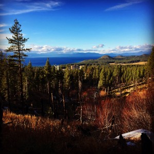 The Kingsbury Bench Ride is actually just a nickname for the 14 mile section of Tahoe Rim Trail (TRT) between Kingsbury Grade and Spooner Summit. This ride can be done as an out & back from either end or as a one-way ride with shuttle. Most riders opt to start out at Kingsbury and head north as it’s got a little less elevation gain than coming south along the trail from Spooner. From the Kingsbury North TRT trailhead this is a very pleasant ride up to the Bench, which sits pretty much at the halfway mark between the two trailheads. The Bench is an actual wooden bench that was built and installed by a local service club many years ago. It sits along the ridge below South Camp Peak, which is the highest point along this section of the Tahoe Rim Trail. Lunch or at the very least a stop for a snack to enjoy the view from the bench is mandatory on this ride. Whichever direction that you choose to ride you’ve got approximately 7 miles of gradual climb to get to The Bench and a really fun, mostly downhill, 7 miles of moderately technical descent. As far as technicality goes, this ride is fairly mild as far as most Tahoe trails go but keep in mind that there are many granite boulders and rocks in the trail. Those of you not used to Tahoe riding will likely find it to be fairly technical. This ride is very similar to the infamous FlumeTrail in that you’ll enjoy beautiful views of the lake and surrounding mountains. It is, however, not as busy as the Flume Trail and we find it an easier ride as it does not have the initial 5 mile gruel of a climb that the Flume Trail greets you with when you ride out of Spooner Lake State Park.
 For those wanting a little bit of a longer ride we suggest doing this from north to south and instead of stopping at the Kingsbury North Tahoe Rim trailhead continuing on to Van Sickle. At the Kingsbury North intersection hang a right (towards Castle Rock) and stay on the Tahoe Rim Trail for another 2 miles. This section is mostly downhill and super fun! Here you’ll cross Kingsbury Grade and continue on the Rim Trail for another 2 miles to the Van Sickle intersection. This section is a pretty grueling & rocky climb, but it does have a couple of spots with magnificent views. Take a right down Van Sickle to get to the Stateline casino corridor and the Heavenly Village.
Call us for a shuttle! (775) 790-6375
Van Sickle Downhill
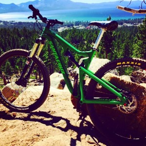
People are always asking us about shuttles to downhill mountain bike trails that involve little to no climbing. Van Sickle is one of only 2 (Hawley Grade in Meyers is the other one) that we currently know of, though there is at least one more being built at this time. Van Sickle is a multi-use trail and it does get very busy with a lot of hikers, especially on summer weekends. Remember, we mountain bikers are last on the yielding totem pole, so be sure to stop and get to the side of the trail when you encounter hikers or horses. If you can avoid riding this at peak usage times, you’ll have a much more enjoyable (and faster) ride. From the drop off point at the Tahoe Rim Trail (TRT) Kingsbury South Trailhead, it’s just one easy mile along the TRT to get to the intersection where Van Sickle drops down towards the lake and the casino corridor. Once there, you’re in for a super fun and somewhat technical 3 mile downhill. There are a few spots where the trail is pretty narrow with significant drops off the side so if you were to get squirrelly there could be consequences. In addition to some granite rock obstacles, there are also a couple of small creek crossings and tight switchbacks. For relatively little work to get to the downhill, this ride sure delivers making it one of my favorites in South Tahoe. See you on the trail – Kat
Mr. Toad’s Wild Ride
 So we’re constantly being asked by our out of town clients which are the best mountain biking trails in Tahoe. Toad’s always makes the list! When it comes to a true technical downhill this is the best that South Lake Tahoe has to offer. It is also the one that we most often shuttle people to. For those die-hards that like to pedal tough and long climbs, you can easily do this without a shuttle. But it’s a good 7 mile climb along the road before you even get to the single track at the Big Meadow Trailhead. From there it’s another 4.5 miles up the Tahoe Rim Trail to get to the intersection for Toad’s. Even with a shuttle, this is not a ride for the faint of heart. From our drop off point you will still have a 2.5 mile climb (that doesn’t sound so bad after reading the last bit about riding this in its entirety now does it?). The climb takes about 45 minutes to an hour and there are certainly sections where most of us have to get off our bikes. When you hit the ridge just above treeline, the views of the Tahoe basin are amazing! This is a great place to stop, catch your breath and fuel up. From there you have a little more work before the fun begins. Once you’ve rounded the rocky left hand uphill turn through what I like to call the “bear cave” the hard part is behind you. This is where I usually stop to put on my pads. Pads you ask? YES – use them! After a short downhill, still on the Tahoe Rim Trail, you’ll come into Tucker Flat which is the intersection of Mr. Toad’s Wild Ride AKA Saxon Creek Trail AKA 18E13. The Tahoe Rim Trail continues to the right towards Armstrong Pass. Hang a left here – this is Mr. Toad’s Wild Ride. Hang on and enjoy the ride! Where there are a couple of trails that jut off to the left, just stay to the right on the main trail. There are many, many technical features along the trail but you can see pretty much everything in advance which gives you the time to decide whether to tackle it or not. There is, however, the sneaky staircase. You’ll enter it while in a right hand turn. It’s very ride-able but it is a long one and the steps get a little steeper as you go. Most wrecks here happen when the rider tries to stop midway through, so if you can just hang on and ride it out your odds are better. While the top half of the ride is very technical, the bottom turns into a flowy, curvy, fast trail with awesome bank turns. Once you hit the gravel service road at the bottom follow it out and up about 1/4 mile into the paved parking lot on Fountain Place Road. From there make a left to get back out to Oneidas Street or a right to get to Powerline Trail or to Corral Loop. See you on the trail – Kat
Call us for a shuttle! (775) 790-6375